How To Find Your Property On FEMA’s Flood Insurance Rate Maps

What are FEMA flood maps?
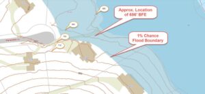
FEMA’s Flood Insurance Rate Maps (FIRMs) or just Flood Maps are provided after a flood risk assessment has been completed or updated for a community.  This study is known as a Flood Insurance Study.  The FIRM gives you the Base Flood Elevations (BFEs) and insurance risk zones in addition to floodplain boundaries.  The FIRM may also show a delineation of the regulatory floodway.

Once the “insurance risk zone”  (commonly referred to as the flood zone) is determined, actuarial rates, based on these risk zones, are then applied for newly constructed, substantially approved, and substantially damaged buildings.  FEMA uses these rates to determine the insurance rate you will pay for flood insurance

FEMA’s Digital Flood Maps

FEMA discontinued the production and distribution of paper flood maps in 2009 as part of its Digital Vision Initiative. This affected all the Flood Maps, boundary information, and study reports. However, clients can still view the products for free through their website or buy them in digital format.

To view these flood maps online, go to FEMA’s Map Service Center and key in your address (hi-lited area shown here) search for your home.  This will prompt you to then select the map that covers your area.  The Flood Maps are somewhat cumbersome to use online. It is best to go through the tutorial on the bottom right of the address search page for an easier and more effective use of the GIS map.
author avatar
Surveyor

More Posts

Professional drone surveying an active construction site with cranes and workers, collecting aerial data for engineering and land surveying projects.
land surveying
Surveyor

Drone Surveying Keeps Projects on Track

Greenville has had another wild week. Storms rolled through, power flickered, and satellite signals went haywire—just when survey crews were trying to finish their work. For many land surveyors, this kind of weather means waiting it out. Wet soil, unstable GPS connections, and broken power lines can stop projects fast.

Read More »
Land surveyor using tripod equipment during a flood elevation survey at a residential property site
flood damage
Surveyor

Why You Need a Fresh Flood Elevation Survey Now

If you live in Greenville, you’ve probably seen plenty of news about growth, new construction, and changing flood maps. But the latest update from the U.S. Geological Survey (USGS) adds a new layer of urgency. Just this week, the agency released a fresh landslide hazard brief for the Southern Appalachians—right

Read More »
Construction survey stakes and bulldozer preparing a new subdivision site with homes being built
construction
Surveyor

Why Every Subdivision Needs a Construction Survey First

Greenville is growing fast. New subdivisions seem to appear every month, and neighbors are starting to notice the traffic, the drainage, and the trees coming down. When a developer gets approval for a new neighborhood, the excitement begins, but so do the concerns. This is where a construction survey makes

Read More »
Two neighbors arguing over a wooden fence line, illustrating a boundary survey dispute between property owners.
boundary surveying
Surveyor

Boundary Survey Disputes: What To Do When They Go Wrong

If you own property or plan to buy a home, chances are you’ve heard about boundary survey disputes. These disagreements happen when neighbors argue over where one property ends and another begins. A boundary survey is supposed to show the exact lines of your land, but sometimes, things get messy.

Read More »
Surveyor using a total station during a topographic survey in tall grass field
land surveying
Surveyor

Tick Season Delays Your Topographic Survey Plans

If you’re planning a topographic survey this year, you might be surprised to hear that one of the biggest challenges isn’t equipment or permits—it’s ticks. Survey crews across the country have been sharing frustrations online, with one Reddit thread even calling 2025 “the year of the tick.” Add in the

Read More »
Surveyor conducting a property survey in a Greenville neighborhood to mark property boundaries and prevent disputes
boundary surveying
Surveyor

The Importance of Property Surveys

If you own land or a home, an accurate property survey isn’t just nice to have—it’s essential. Greenville’s neighborhoods are growing fast, and knowing exactly where your property lines are can save you from big headaches later. Without a clear survey, you could end up in boundary disputes, face delays

Read More »